Topic Overview: SONAR and RADAR
Sound Navigation Ranging, or SONAR, is a type of remote sensing. It is used to gather facts about things that are far away or cannot be seen clearly. SONAR involves making sounds and listening to the way they bounce off objects. The echoes provide very useful information about the objects. For example, bats use a special kind of SONAR called echolocation to "see" where they are flying, avoid danger, and catch insects.
Scientists use SONAR to "look" at the ocean floor. They send out sound waves from a ship floating on the ocean surface. The sound waves bounce off the ocean floor. Scientists listen to the echoes. The sounds of the echoes tell the scientists the distance between the ship and the ocean floor. By mapping these distances, the scientists can create pictures of the mountains and valleys on the ocean floor.
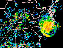
 Radio Detection And Ranging, or RADAR, is another type of remote sensing. It is a lot like SONAR. It is also used to gather facts about things that are far away or cannot be seen clearly. The difference is that RADAR does not use sound waves to remotely sense objects. Instead, RADAR uses electromagnetic waves. The echoes of the electromagnetic waves tell us about objects. You may have even seen a RADAR map on television. Meteorologists use RADAR data to predict weather. Air traffic controllers use RADAR to track airplanes. The image to the left is a NEXRAD image of Hurricane Fran off the East Coast of the United States on Sept. 5, 1996. Radio Detection And Ranging, or RADAR, is another type of remote sensing. It is a lot like SONAR. It is also used to gather facts about things that are far away or cannot be seen clearly. The difference is that RADAR does not use sound waves to remotely sense objects. Instead, RADAR uses electromagnetic waves. The echoes of the electromagnetic waves tell us about objects. You may have even seen a RADAR map on television. Meteorologists use RADAR data to predict weather. Air traffic controllers use RADAR to track airplanes. The image to the left is a NEXRAD image of Hurricane Fran off the East Coast of the United States on Sept. 5, 1996.
Image courtesy of the Weather Services International Corp. and NASA though the Global Energy and Water Cycle Experiment Continental-Scale International Project. |


