Topic Overview: Pictures from Space
Taking pictures is a form of remote sensing. Pictures can give us facts about people, places, or things from a distance. Pictures can teach us about faraway lands. They can show us what plants and animals live there. They can also show us what people wear in other countries.
We can learn all this in our own homes by looking at pictures. And we can learn it in an instant. Have you ever heard the phrase "a picture is worth a thousand words?" It means a picture can teach us as much as 1,000 words can. Well, maybe not exactly 1,000 words worth. But a picture can give us a lot of facts. And it takes a lot less time to look at a picture than to read a thousand words!
How do images get on pictures? Well, all objects give off or reflect light. Cameras record that light on film. Most cameras record visible light. Visible light is the light that we can see. It includes all the colors of the rainbow. However, we cannot see all types of light. One type of light that we cannot see is infrared light. Special cameras can "see" infrared light, though. These cameras can be used to record infrared light. We can look at those pictures to find out about the amount of infrared light that objects give off or reflect.

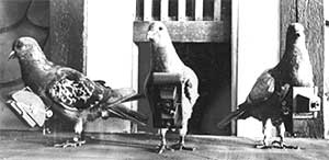
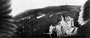
Often pictures are taken from high above the ground. This allows the photographer to fit a much larger area in the picture. Pictures taken from the air are called aerial photographs. These pictures can give us facts about large areas of Earth. Pigeons took some of the earliest aerial photographs! In 1903 Julius Neumbronner strapped tiny cameras to pigeons. The cameras had timers on them. They snapped pictures as the pigeons flew over Europe. At the right is a picture of a castle taken by one of the pigeon-mounted cameras. Can you see the pigeon's wings?

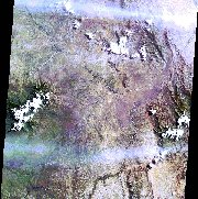
 Pictures can even be taken from space shuttles or satellites orbiting Earth! Such pictures are called satellite images. Satellite images record visible light reflected by objects on Earth. They also record infrared light. Satellite images allow scientists to look at very large sections of Earth. Some of these images show nearly the whole planet at one time! Pictures can even be taken from space shuttles or satellites orbiting Earth! Such pictures are called satellite images. Satellite images record visible light reflected by objects on Earth. They also record infrared light. Satellite images allow scientists to look at very large sections of Earth. Some of these images show nearly the whole planet at one time!
Scientists can learn a lot from these images. They can locate objects on Earth by looking at the light they reflect. Satellite images can show the areas of Earth covered by plants. Satellite images can also show clouds covering the planet. Satellite images help scientists keep track of what is happening on Earth. That makes satellite images important tools in remote sensing.
Digital imagery provided by Space Imaging EOSAT. |


