|
|
The Land of Korea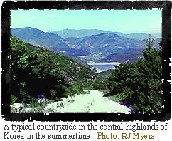 Korea is a beautiful land largely covered by mountains,
as a glance at the photo to the right or at a topographic
map will show. The main mountain range, the T'aebaek-san (san means "mountain" in Korean), covers
most of North Korea and extends SSE through the east center of the peninsula. The highest
peak is the dormant volcano Paektu-san on the Chinese border. The mountains are cut by
many narrow river valleys, but the only wide valleys and plains are along the west coast.
(As you look at photographs in this and other sections of the module, keep an eye out for
mountains in the background. They are almost everywhere.) The
ruggedness of the terrain is also reflected in the intricate pattern of different types
and densities of plants seen on a satellite vegetation index
mosaic. Korea is a beautiful land largely covered by mountains,
as a glance at the photo to the right or at a topographic
map will show. The main mountain range, the T'aebaek-san (san means "mountain" in Korean), covers
most of North Korea and extends SSE through the east center of the peninsula. The highest
peak is the dormant volcano Paektu-san on the Chinese border. The mountains are cut by
many narrow river valleys, but the only wide valleys and plains are along the west coast.
(As you look at photographs in this and other sections of the module, keep an eye out for
mountains in the background. They are almost everywhere.) The
ruggedness of the terrain is also reflected in the intricate pattern of different types
and densities of plants seen on a satellite vegetation index
mosaic.The climate of Korea is not unlike that of the eastern United States, with hot wet summers and cold dry winters. The average summer and winter temperatures and rainfall are shown in the temperature and precipitation map. The combination of high topography and high rainfall in the North provides for ample hydroelectric power. Korea is one of the most densely populated countries in the world, so every square inch is committed to some specific use. The land use map shows how the land is divided between wet and dry farming, forestry, and urban/industrial use. Can you see any correlation between the patchy distribution of different types of land use and the topography? Another way of seeing Korea that complements the maps and photos shown in this section is to view it from space.
[
Korea Today ] [ The Land of Korea ] [ The People of Korea ] [ Home ] [ Teacher Pages ] [ Modules & Activities ] |
![]()
HTML code by Chris Kreger
Maintained by ETE Team
Last updated April 28, 2005
Some images © 2004 www.clipart.com
Privacy Statement and Copyright © 1997-2004 by Wheeling Jesuit University/NASA-supported Classroom of the Future. All rights reserved.
Center for Educational Technologies, Circuit Board/Apple graphic logo, and COTF Classroom of the Future logo are registered trademarks of Wheeling Jesuit University.