
 |
Living with the Virunga Volcanoes Nyiragongo
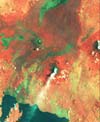
in Eruption (download TIFF) This enlargement,
from the March 1975 MSS 3-2-1 image of western members of the Virunga chain, is
specifically stretched to show lava flows around the volcanoes. The plume is coming from
the main crater of the volcano Nyiragongo. The large crater to the northwest is the
volcano Nyamlagira. Both of these volcanoes have erupted many times during this century.
Nyamlagira has erupted more than 30 times in the last 100 years, with recent eruptions
occurring in 1980, 1981, 1984, 1986, 1989, and summer of 1994. Lava flows, seen in the
image, originate from the central crater and the lower slopes, flowing in almost all
directions. Fresh flows do not yet have much vegetation on them. Nyiragongo
in Eruption (download TIFF) This enlargement,
from the March 1975 MSS 3-2-1 image of western members of the Virunga chain, is
specifically stretched to show lava flows around the volcanoes. The plume is coming from
the main crater of the volcano Nyiragongo. The large crater to the northwest is the
volcano Nyamlagira. Both of these volcanoes have erupted many times during this century.
Nyamlagira has erupted more than 30 times in the last 100 years, with recent eruptions
occurring in 1980, 1981, 1984, 1986, 1989, and summer of 1994. Lava flows, seen in the
image, originate from the central crater and the lower slopes, flowing in almost all
directions. Fresh flows do not yet have much vegetation on them.Nyiragongo had a lava lake in the central crater from 1927 through 1977, when an enormous flank eruption emptied the lake. Lava flowed at speeds of 64 kph (40 mph) southeast toward the towns of Goma and Gisenyi (gray-green spots on lower right shore of Lake Kivu), stopping just short of the Goma Airport. Seventy people died in that eruption. This image shows the volcano while the lava lake was still intact. Recent eruptions occurred in 1983 and in the summer of 1994. Nyiragongo and Nyamlagira are the active members of the Virunga chain, while the others are dormant. Gorillas live on the slopes of the dormant volcanoes, but not on the slopes of the two active volcanoes. People, on the other hand, live and farm on the very slopes of the active ones. Comparing the Virunga political map with the satellite image shows that several refugee camps are located on the slopes of Nyiragongo. The 1994 eruption occurred at the same time the camps were forming.
If you carefully compare the 1975 MSS image with the 1994 radar image, you will be able to find lava flows in the radar image that formed after the MSS image was taken. Constant eruptions of Nyiragongo and Nyamlagira make life around them precarious, yet people continue to live nearby because of the richness of the volcanic soils that cover the slopes and valleys between the volcanoes. Detailed information about the radar image, the instrument that took it, and the Shuttle missions on which the instrument flew can be found at the JPL Imaging Radar home page.
[ Peoples of Central Africa ] [ Famine in Rwanda ] [ Home ] [ Teacher Pages ] [ Modules & Activities ] |
HTML code by Chris Kreger
Maintained by ETE Team
Last updated April 28, 2005
Some images © 2004 www.clipart.com
Privacy Statement and Copyright © 1997-2004 by Wheeling Jesuit University/NASA-supported Classroom of the Future. All rights reserved.
Center for Educational Technologies, Circuit Board/Apple graphic logo, and COTF Classroom of the Future logo are registered trademarks of Wheeling Jesuit University.